Saturday, December 27, 2014

It was a Warm, Green Christmas in 2014!


There was no white christmas this year in the Tri-State region. In fact it was one of the warmest Christmas eves and Christmas days in decades! It was also one of the wettest as well! The graphic below was released by the New York City National Weather Service office. It shows the records, as well as official temps and rainfall for the area's weather station. Bridgeport, CT is the closest station to my hometown. However, check out how warm it got at LaGuardia airport in New York! It got up to 63 degrees on Christmas day, that beat the record by 6 degrees from 24 years ago in 1990! 

It was also one wet, Christmas Eve with it being the wettest on record at Islip, NY and Kennedy, NY. 

Thursday, December 18, 2014

One of the Best Tornado Videos of the Year! Double the Trouble - Sister Tornadoes in Nebraska 6/16/2014


Looking back at some of the videos I saved to my "Watch Later" list on YouTube, I discovered this amazing video from June 16, 2014. It's double the trouble with this violent dual tornadoes spinning up in the plains. It happened from from Stockton to Pilger, Nebraska . The storm chasers at WeatherStorm.net, a severe weather blog, caught this incredible storm on video. These two tornadoes are a part of the same Tornado Family, which means they are separate tornadoes forming form the same supercell, taking a parallel path. 


The same system was caught on camera by other chasers, including the chasers at stormchasingvideo.com. It's an amazing site to see one tornado but to see two right next to each other is incredible! 


Friday, December 12, 2014

A Scene from The Day After Tomorrow? Tornado Strikes Los Angeles (Video & Photos)

It's a scene straight out of the movie The Day After Tomorrow, a tornado has struck Los Angeles! Well, it's not quite the same as the dramatic movie but it was a tornado that struck the city of Angels this morning (12/12/2014). What is believed to be the tornado was caught on camera below. Disclaimer: Taking video in a situation like this is extremely dangerous, you should be taking shelter and only recording or photographing from a secure location.
The Los Angeles National Weather Service confirmed that the storm was in fact a EF-0 Tornado. Stating
      "A SMALL TORNADO EF0 CREATED DAMAGE IN SOUTH LOS ANGELES 
       FROM THE INTERSECTION OF S. VERMONT AVE AND W. GAGE AVE 
       TO 57TH STREET AND S. FIQUEROA ST. DAMAGE REPORTED 
       INCLUDES, AN APARTMENT COMPLEX ROOF, TREES, TWO 
       RESIDENTIAL ROOFS, AND DAMAGE TO A STEEL BILLBOARD. EF0 
             WINDS SPEEDS RANGE FROM 65 TO 85 MPH." 
As you can see below in the radar image tweeted out by The Weather Channel, the storm itself was very small but still impressive for the area. Tornadoes are not all too common in the southern California area but they're not unheard of either! According to The Tornado History Project, there have been 42 reported/confirmed tornadoes within the Los Angeles COUNTY since 1952! 
Even a water spout was caught on camera off the coast of Newport beach on 12/12/2014!

And in case you forgot what the tornado looked like in the film The Day After Tomorrow, here you go! 


The short lived tornado in LA on December 12, 2014 is apart of the larger storm system that has also brought surfing to the mountains as winds have produced seven foot waves in Lake Tahoe! 

Surf's Up on Lake Tahoe!! Pineapple Express Brings Surfing to the Mountains! (video & photos)

Lake Tahoe, the sixth largest lake by volume in the United States following the five Great Lakes. It resides in the Sierra Nevada, snuggled along the California and Nevada state lines. The lake is a high elevation lake with a depth of 1,645 feet. Pretty impressive right? 

The lake itself is a well known tourist attraction in the summer months, but as the snow begins to fall the surrounding mountains steal the show. However, it wasn't the amazing skiing conditions that made the news this week, it was the surfing that was going on hundreds of miles from any ocean! 

As the pineapple express finally returned to California, bringing with it, beneficial rains, snow. The storm has brought some other impacts, like mudslides and surf on Lake Tahoe! The GIF below shows the wind direction and intensity (closer the lines are the faster the winds) of the storm system as it enter the California coast. These winds blew over Lake Tahoe from the south to the north, the length of the lake. This long fetch created the perfect conditions for surfing at the lake's north end! 
The video above and the Twitter photos below show the  awesome event and the surfers taking advantage of the conditions to catch some waves! It's so cool! 


Blending the Seasons! Plants Don't Know If it's Fall, Winter or Spring!

As the nor'easter finally begins to wrap up and slowly but surely move away from the northeast, it seems some of the plants have the seasons mixed up. As some snow flurries fell yesterday afternoon, I took a quick stroll around the backyard with the dog and decided to take a few photos with my phone. As I walked across the melting snow (just a dusting from the night before) I noticed some snow on the arborvitaes, which looked very festive with Christmas coming up. Then out of the corner of my eye, I noticed a color that was neither brown, nor white or green. A color that should not be found in nature this time of year. This color was a yellow flower. Specifically, a forsythia flower, a trademark of spring. It must bloomed last week when temperatures briefly peaked around 60 degrees. It wasn't even just one flower, there were multiple blooms! There was even some forsythia leaves on the branches.  
In all the photos I took, you can see the dusting of snow in the background. Nature is defiantly confused on what season it is! There's spring blossoms, winter snow, and of course it really is still autumn! 

Snow hangs on to the evergreen branches, creating a festive holiday scene! 

Halloween pumpkin partly eaten by squirrels and covered in a dusting of snow! 


Forsythia flowers blooming with a dusting of snow in the background.  

Even new forsythia leaves have sprouted! 


Sound Effect Snow? 12-11-14

After the surprise Ocean Effect Snow in New Jersey the other day and talking about how unusual it was, another unusual event happened today! This time it was sound effect snow from Long Island sound. 

As this week's nor'easter slowed down and te upper level low caught up to it, we have seen the cold air and moisture wrap all the way around the storm. Even to one point where it was raining in Maine but snowing ins Philadelphia!!!! Crazy! 

As this storm has sat and spun over us, the winds have shifted from the north east to the west and even south west. Usually this wind direction brigs warmer and drier air but being stuck under the trough of low pressure, with all layers of the atmosphere being close to or bellow freezing, there's been NO warming. 

With this south west wind, cold air and relatively warm Long Island Sound, a very faint snow band formed over the sound north into Massachusetts. The wind direction was perfectly aligned with the length of Long Island sound, creating enough fetch and warm water to form the snow showers and flurries. 

I've circled the sound effect snow band on the radar image below. It's faint compared to the ocean effect snow from earlier this week and nothing compared to the Buffalo lake effect storm from November 2014 but it's still very interesting!


Tuesday, December 9, 2014

Jersey Shore Ocean Effect Snow! 12-8-2014

You always hear about Lake Effect Snow (especially after the incredible event south of Buffalo, NY in November 2014) on occasion you'll hear about Ocean Effect Snow near Cape Cod. But it's not as common to hear about it in New Jersey and Long Island! Yet it happened on December 8, 2014! 
Here's a radar image via RadarScope of the ocean effect snow. This snow develops the same way as lake effect. As cold air flows over warm water, the warm water feeds moisture into the cold air, where it condenses into snow and mix precipitation. Due to geography and the typical wind patterns out if the west or north, normally coastal New England and Mid-Atlantic will not experience ocean effect snow. However, the winds out of the northeast on December 8th as well as stubborn low level cold air made for the perfect set up to have Ocean Effect Snow move into the Jersey Shore! 

Below are some tweets that captured the snow lightly accumulating in New Jersey! 


Monday, December 8, 2014

Summer on the Shore - Photos of Charles Island in Milford, Connecticut

So apparently I uploaded these photos to blogger months ago but never got around to finishing the post. So on the evening of a nor'easter, I figured why not post some nice photos from the warm summer evenings we're already missing here in New England. 

These photos were taken with my iPhone one evening in August in Milford, Ct. From this beach you can see our local island, Charles Island. On this particular evening a thunderstorm was moving by just inland, making for a beautiful sunset and some rumbles of thunder! 

What's really cool about Charles Island is the fact that at low tide there is a sandbar that connects the island to the shore (so cool!). However, don't run out to the island just yet! Although it's possible to walk to the island at low tide, the walk takes awhile and many have been caught by the strong water currents flowing back in. 

The island itself has an interesting past, including tales of pirate's treasures and Native American burial grounds, as well as a curse!  Everything that has been built on the island in the last 300 years has burned down, including a hotel! 

The island is a protected bird sanctuary from May to October when many birds are nesting on the island. The island has also been impacted by Tropical Storm Irene, as well as Superstorm Sandy. The exposure to Long Island Sound has taken many trees down as well as causing some erosion. 


Saturday, December 6, 2014

What Famous Paintings Say About the Weather (Photos)

Check out these famous paintings and what they're actually thinking about the weather and climate change. 

"American Gothic" - They don't have smiles on their faces because they're battling a multi-year drought that's causing their farm to fall apart!  
Look at the hair! Now it could be just the hair style of the time or it could be the humidity...just saying!  Portrait of Anne Marie Louise Thelusson by artist Jacques Louis David

At the rate that sea levels are rising, they might not have thought through on building so close to the water in Seaport with the Embarkation of the Queen of Sheba


Vincent Van Gogh's famous Painting "The Starry Night" is actually a painting of Undulatus Asperatus clouds. These rolling clouds didn't have a name back in his day. They sometimes look ominous but usually follow after bad weather has passed! 


Tuesday, November 18, 2014

Radar Image 11/17/14

Here's an image of a small squall line moving through south western connecicut associated with a cold front on Monday Nov 17th 2014. 


Below is the storm velocity image. That shows the winds moving towards the radar station (green) and away from the radar station (red). You can actually see te squall line! Pretty cool! 
Velocity images, like the one above are awesome used to detect rotation in tornadic thunderstorms. When the red and green are touching or wrapped around eag other, it signifies winds rotating. That's a little weather knowledge for you! 

Buffalo New York EXTREME Lake Effect Snow Event 11/18/2014


Buffalo, NY, an all American city at the northern edge of Lake Erie (1 of the 5 Great Lakes). A city with a beautiful view and an unlikely curse. That curse (although it might not be for snow lovers!) is the infamous Lake Effect Snow machine. As cold air runs over the warm waters of the lakes in late fall and early winter months, instability is created and intense bands of snowfall can be formed.  Where these bands of snow showers and even thunder snow set up depends on the wind direction. As long as the wind is blowing and the lake is ice free, this set up will produce snow.

If the transfer of moisture is great enough, the snow can pile up to tremendous amounts. This is what has happened today just south of Buffalo. As of right now at 10pm est on November 18th 2014, the snow is still falling over the same area and it's piling up to astronomical amounts!

To illustrate how intense and localized these snow bands can be see the Tweet below by the National Weather Service in Buffalo. 6o inches of snow in Lancaster, while just 6 miles north at the Buffalo airport, there is only 3.9 inches!
Source: NWS Buffalo


Now back to the video above. It is a time-lapse of the snow band moving inland from Lake Erie just south of Buffalo. You can almost see the moisture being transfer from the lake into the sky and deposited in the form of snow on the land. The ominous wall of white that drags across the water and land is actually falling snow!!  

This event is definitely one for the record books and it's not even over yet! Here are some more photos posted on social media of today's events! It's crazy to see how high the snow has gotten. Hope people just south of Buffalo have some fun games to play while snowed in!
Source: Twitter

Source: Twitter

Poor dog, now he knows what it feels like to be a tiny dog!  

Source: Twitter 

If it was a Marshmallow World, this guy would be rich! 


Source: Twitter 

Oh the days of summer, it feels like it was just yesterday! 


Source: Twitter 

Sunday, November 16, 2014

It's a 'CAT'urricane!

It's a 'CAT'urricane!!! Well, not really, it's just a funny GIF I came across on Tumblr. It's a well known fact that cat's rule the internet. Let's face it, how many times have you been completely drawn into watching a cat do something funny on youtube, or see a funny cat photo?  It could be every day!  

Weather can also be a very intense and crazy part of the internet as well. Weather is like the cat's cousin, and 10th in line to the throne. It has it's moments but sadly it will never completely take over the internet like cats do. But what if we combined them? 

So as part of your daily dose of the internet ruler (cats) enjoy watching this cat spin on top of a hurricane all day long! Cat's and weather should go together more often! 

Saturday, September 6, 2014

The Most Spectacular Fog Videos!


Fog, a mysterious and majestic creature that slowly inundates the land and sea; turning the familiar to the unknown and clarity to haze.

Check out my latest article on Hubpages called The Most Spectacular Fog Videos!  

This article briefly defines what fog is and the various types of fog that exist. Yup, you read that correctly, there are different types of fog! 

The article also features a number of amazing fog videos, who would have thought fog could be so cool! 


Tuesday, May 20, 2014

Moore Tornado - One Year Anniversary May 20th

It was one year ago today that the town of Moore Oklahoma was devastated by a massive EF5 tornado. The tornado injured up to 377 people, killing 24, including seven children at Plaza Towers Elementary School. Winds exceeded 210 mph and the tornado reached an incredible width of 1.3 miles wide. The storm destroyed 1,150 homes and caused $2 billion in damages. The people of Moore are still recovering a year later.

A true monster of a storm. The tornado grew fast from it's small funnel to it's mile wide mass of swirling debris and clouds. The video below shows how quickly this storm grew!

The next video is a time lapse view of the tornado from a news helicopter. Watch as the black behemoth rides across the flat lands of Oklahoma connecting the dark sky to the green land. 


Thursday, May 15, 2014

Fire Tornadoes in California! 5/15/2014

It's not every day you see a swirling mass of fire spinning violently up from the ground but today was the day in California! As the unusual wildfire storms just north of San Diego, this spectacular and extremely dangerous situation was caught on tape! 
This video was taken in San Marco, CA. Although fire season is usually later in the year, the extensive and extreme drought the state has been suffering though has resulted in an extremely early fire season. As seen below in the US Drought Monitor, the whole state is in extreme to exceptional drought conditions. 
With extreme drought like this, fire season is going to be long and damaging! 

Now what is a fire tornado? Also known as a fire whirl, fire devils and firenadoes. These small vortexes form within wildfires when extreme heat combine with strong winds to produce eddies that carry flames into the air like a small tornado. Most fire tornadoes are one to three feet wide, reaching up to 100 feet tall. However, there have been occurrences when the whirlwinds have gotten up to a 1,000 feet wide! Since the fire whirl is formed from the extreme heat of a small area, temperatures become a factor in these micro storms. Inside the core of the fire tornado, temperatures can reach an incredible 2,000 degrees F! 

Wednesday, May 14, 2014

Tornado Takes a Beach Day Part 2 - Myrtle Beach July 6, 2001


Like the water spout that came ashore in Carolina Beach on August 18, 2011. This water spout rides directly along the shore, ruining every one's beach day! It's as if the tornado is going for a jog down the beach. Watch as it grows, gathering sand and water into it's funnel. Since the video is from 2001, it is kind of grainy but still impressive! 

The tornado moves up the coast and past the high rise condo that the observer is recording the film. Although this video is older, it still zooms in enough to see the swirling vortex at an unusually close vantage point!  

Although impressive, its good to see no one on the beach. This storm is fairly strong and could have seriously hurt or even killed anyone on the beach! 

Sunday, May 4, 2014

Italy Tornado Get's Awfully Close! (video)


Check out this amazing video out of Italy! A weak tornado formed on April 30, 2014 and was caught on camera from a workplace. Watch as the tornado swirls just outside the large glass windows of the building, snapping trees and glass. The workers rush to find cover near the center of the building but that's pretty much all they did right! However, you can't really blame them, tornadoes are not as common in Italy as in, say Oklahoma!

Although tornadoes are no strangers to the country of Italy, the frequency is not as great as it is in Tornado alley in the United States. On average all of Europe sees about 300 tornadoes every year. Compare that to the 1,274 tornadoes annually in the United States!

Thankfully the people in the office building are ok and they have some great footage but let's hope they learn to drop the camera next time and seek shelter!

Saturday, May 3, 2014

Climate Model Turned Into Stamp! (video)

This is pretty cool! On Earth Day, April 22, 2014, "the U.S. Postal Service officially unveiled a new Forever international-rate stamp inspired by a simulation of sea surface temperatures from a NOAA model of the Earth's climate."


I'm no stamp collector but this would be something cool to have! Turning computer models, and science into art is always interesting! Maps themselves are really part art and part science! Visual representation is great for sharing information but also allows for readers interpretation, which can result in art!  

Check out the video below of how the computer model was transformed into the stamp! 


Friday, May 2, 2014

Baltimore Urban Landslide! (Video)

When you think landslide, you probably think a sludge of mud sliding down the side of some remote mountain but you probably don't think one could happen right in the heart of a city!

This week the east coast of the U.S. experienced  a complete deluge of spring rain as a slow moving storm system moved from west to east. Many ares from the Mid-Atlantic to Southern New England saw 3-5 inches of rain in a 30 hour period. In fact Central Park in NYC saw an amazing 5.12" of rain! That's more than a whole months worth of rain!

Even though the rain was very impressive and many areas experienced flooding, what took the top spot on most news channels was the urban landslide in Baltimore, Maryland! In the Charles Village neighborhood of Baltimore, on 26th street a retaining wall gave out under the pressure of the heavy rain. This caused the wall, sidewalk, street and cars to fall 75 feet to the train tracks below!

This incredible urban landslide was even caught on camera! The video below is incredible yet scary at the same time!


Thursday, May 1, 2014

Saturday Evening Post - Weather Obsession!

Normally when I hear 'Saturday Evening Post' I think of the iconic Christmas paintings by Norman Rockwell or his other great iconic work. So it was a surprise to see a really cool image circling the net (mostly Twitter) that held the Saturday Evening Post trademark. 

This image was an illustration focused on the weather! The cover to the infamous magazine's May/June 2014 edition features an illustration of a man climbing to a ledge to look at a tornado and a giant tidal wave! 

The article associated with the really cool cover is titled "Weather Obsession what's Behind the Fascination with Forces Beyond Out Control?" 

I actually liked the cover so much, I took a screen shot of it and use it as my wallpaper on my phone! I'll hopefully will be getting to the store soon to buy a hard copy of this awesome issue! 

What do you think of the cover? 


Wednesday, April 30, 2014

Tornado Infographic

With the tornado season now in full swing in the United States, I decided to do a little web surfing and I found this great infographic! 

Infographic displays copious amounts of information in easy to comprehend visual styles.  

This infographic that sources The Weather Channel focuses on general statistics for tornado occurrence in the United States.  

The graph shows the average amount of tornadoes per state, per year.  I was surprised that Connecticut has the highest annual occurrence of tornadoes in New England with an average of 3 tornadoes a year! 

The infographic also shows information on the most deadly tornadoes since the 1950's. No surprise that the Joplin tornado from 2011 tops the list.  

So check out this graph for some great stats on tornadoes! 


Tuesday, April 29, 2014

Blue Skies Above: Hurricane Sandy Cause Storm Surge in Ft Lauderdale! (Video)


Believe it or not, but this video is actually a result of Hurricane Sandy! Yes, the storm was so massive, and such a monster, that it sent storm surge all the way down the east coast to Ft. Lauderdale Beach in Florida.  On the morning of October 28, 2012, Hurricane Sandy was about to take her left hand turn into the coast of New Jersey, but it sent swells out in all direction, impacting people and beaches far and wide!  

These swells, combined with an astronomical high tide, sent the ocean crashing over the dunes and right into the stress of Ft Lauderdale Beach. Pretty impressive considering the storm was close to 1,000 miles to the northeast! Sunrise Blvd was inundated with water, shocking many considering the skies were crystal blue and the weather was beautiful.

It truly is remarkable to see the strength and power of these storms!

Monday, April 28, 2014

Mayflower Tornado - April 27, 2014


Three years to the day of the Tuscaloosa Tornado Outbreak, the first major tornado outbreak of the 2014 season has begun. On April 27, 2014, Mayflower, Arkansas was hit by a strong tornado. The strength of which has yet to be determined but the storm left at least 14 dead and destroyed homes and businesses to the basement slabs.  According to The Weather Channel, this included a $14 million intermediate school that was set to open it's doors this fall.

The video above was taken of the storm from a distance as it eerily flowed over the landscape in silence.

Below is incredible video from the AP, taken just after the storm moved through. Brian Emfinger used a drone to capture the ariel extent of the devastation has the tornado passed over an interstate and flattened buildings. Besides the amazing shots the drone captures, it begs the question, can drones help in recovery after a natural disaster? Or even help access the damage in a more affordable process?

Sunday, April 27, 2014

Tuscaloosa Tornado April 27, 2011


Today marks the third anniversary of a devastating disaster, a tornado outbreak for the record books. From April 25-28, 2011 a massive tornado outbreak befell the southern states, causing massive damages in order of $11 billion and changed thousands of lives forever. Sadly the entire outbreak resulted in 358 confirmed deaths.

The outbreak was one of many extreme weather events in 2011.

On the third day of the tornado outbreak, a massive F-4 tornado raced from Tuscaloosa to Birmingham, Alabama. It caused 1,500 injuries and 65 fatalities in it's 80 mile long path. The storms peak winds reached 190 mph, leveling whole neighborhoods.

The storm beard down on the metro area of Tuscaloosa.  The scene of a tornado approaching a highly populated area is one that many have not witnessed in years, if not decades. In our technological age, this storm was caught on camera in hundreds of different perspectives, from television web cameras to mobile phone recordings.

The video above is taken by an individual as the tornado moves right through the parking lot in front of him! It's pretty INTENSE and not something I recommend any body do!


Below is video of a local television station covering the storm right as it forms from a dark funnel into a massive black tornado tearing up the urban landscape!


Finally, here's the ariel views taken a day after the Tuscaloosa tornado on April 28, 2011. As you can see the damage was extensive and many areas were leveled!


Water Spout Takes a Beach Day! (Video)


The above 'tornado' video is pretty AWESOME! I only say this because it shows the amazing beauty of nature while not causing any injuries or too much damage.

This storm starts off as a waterspout, since the vortex is over water and technically turns into a tornado when it crosses onto the beach. Watch as the weak funnel turns color as it begins to pick up sand on the beach. The vortex is weak like most waterspouts are but powerful enough to pick up a couple of beach umbrellas and throw them around like Dorothy's house in the Wizard of Oz!

The storm occurred in Carolina Beach, North Carolina on August 18, 2011. The waterspout first formed .75 miles off shore and moved inland about .5 a mile before dissipating.

The storm made for one heck of a Beach Day!

Saturday, April 26, 2014

Storm Surge Hits ChiTown!


It's not often that you see storm surge in a Major city, although if sea levels continue to rise it may become all too familiar. Older infrastructure built in low-lying areas out of connivence are now being threatened by ever rising water levels and increased erosion. However, the video above is not a ocean front shore but a lake front! Lake Michigan to be exact and the highway running along side the rising surf is the infamous Lake Shore Drive in Chicago.

You may think that just because Chicago is on a lake, they can't experience storm surge, but you would be wrong. Lake Michigan is so large that strong winds and storms can easily pile the water up on one side of the lake.

This video from September 30, 2011 shows that even in a major city on a lake, the power of water can be dangerous! Lake Michigan never makes it to Lake Shore Drive but it engulfs the park area next to the highway used for walking, running and biking. Like most storm surges, the unsuspecting waves catch a few pedestrians and cyclist off guard. Some even almost get washed away.

Forest Swallowed by Sinkhole in Just Seconds! (Video)

In this amazing video from August 2013, entire trees are swallowed up by a large sinkhole beneath a lake in Louisiana. It's stunning to see what appears to be 50 foot trees just sink gracefully into the muddy waters, never to be seen again. However graceful and amazing, this sinkhole would have been disastrous if it had occurred in a populated area!

Sinkholes are caused for a number of reasons. They occur when subsurface layers are dissolved (natural limestone erosion) or removed (example: mining). When the subsurface layer is removed, an area of open space appears, which then causes the surface above to sink into the giant hole.

This particular sinkhole is amazing due to it's size, it's position under a water source and it being caught on film! In the petroleum rich area of Louisiana, one reason for this particular sinkhole could be the collapse of a salt dome. Salt domes are often found near petroleum deposits.


Sunday, February 9, 2014

The Great Blizzard of 2013 One Year Later

Radar during the storm when an intense snow band dropped up to 3 inches an hours of snow, including some hail and thunder snow! 
Total snowfall from the blizzard mapped by NWS Boston, south central CT (where I live) was the bullseye (dark purple) with over 30 inches of snow! 

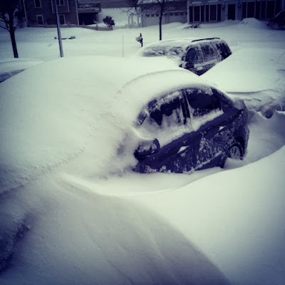
My driveway on the morning of February 9th 2013! 

The satellite image of the powerful storm as it moved away from the coast. It looks almost like a hurricane! 


Monday, January 6, 2014

Freezing rain yesterday, 52 degrees today, below zero windchill tonight!

Crazy weather of New England continues as we saw freezing rain yesterday (see pics below) followed by rain and dense fog overnight and into this morning. Now temps are in the low 50's, we were just -2 degrees Saturday morning! Expecting heavy rain and wind to move through this morning followed by bitter cold with windchill a tonight and tomorrow approaching -15 degrees!!!!! 


Saturday, January 4, 2014

Sub-zero Temps! 1/4/14

Well according to weatherbug, we dropped below zero last night! Which doesn't happen often when you live near Long Island sound! 

Friday, January 3, 2014

Subzero cold forecasted for 1/3/14-1/4/14

Sub-zero temps predicted across all of CT tonight! Possibly coldest night in decades! Here's what NBC CT is predicting!