
Sunday, December 30, 2012
New WxEdge Article 12/30/12
Just finished up a new article for WxEdge.com about how "That Pesky Rain/Snow Line Strikes Again" in reference to how the snow storms have been going this year in light of yesterday's surprise change to rain during the nor'easter on 12/29/12.

Friday, December 28, 2012
My latest WxEdge Article 12/28/12
Finally got around to writing another article on WxEdge.com, a local news affiliate site about the weather, which I have been a contributor to since last February. This article is about the latest Drought Monitor released on Christmas Day and the large area of the country that is experiencing at least abnormally dry conditions! Check it out here: 2012 Drought Continues...Just Not for CT


Thursday, December 27, 2012
Gift for a weather geek!
This is what you get as a gift from a friend when your a weather geek! A weather map on a tshirt! I love it!!

Monday, December 10, 2012
Foggy December Day 12/10/12
It's almost mid December and here in CT a warm front straddles the coastline. Temperatures range from the upper 40's to mid 50's this morning with a chance of hitting 60 degrees this afternoon. Although the temps make for a more comfortable day with no overcoat, it sure is a buzz kill when it comes to the Christmas Spirit!
With most warm fall days comes the fog and today is no different! As moisture streams northward it hits the cooler air causing it to condense at ground level and creating what we see as fog. Along the CT coast and CT valleys, this fog can be very dense. Below are some photos I took with my iPhone of fog at the beach. As you can see the first picture is of a flag pole at Anchor Beach, the rock it sits on is only 20-25 feet away from the street, over the water, yet it's hard to see! The second picture actually shows concrete steps that were removed due to damage from Hurricane Sandy with fog in the background! And finally the last picture is of Woodmont beach in the fog!


With most warm fall days comes the fog and today is no different! As moisture streams northward it hits the cooler air causing it to condense at ground level and creating what we see as fog. Along the CT coast and CT valleys, this fog can be very dense. Below are some photos I took with my iPhone of fog at the beach. As you can see the first picture is of a flag pole at Anchor Beach, the rock it sits on is only 20-25 feet away from the street, over the water, yet it's hard to see! The second picture actually shows concrete steps that were removed due to damage from Hurricane Sandy with fog in the background! And finally the last picture is of Woodmont beach in the fog!
Tuesday, December 4, 2012
Fire Island Cut in two by Hurricane Sandy
In the past few days I've seen a few different articles on the Internet about the new inlet created by Hurricane Sandy on Fire Island New York. Thankfully it happened Ina wildlife refugee area and there were no homes destroyed at this section. If you didn't know Fire Island, like many coastal areas of the east coast is a barrier island. A barrier island is a small strip of land that parallels the main coast. It is a transitional environment that changes with constant beach erosion and storms. In fact the islands actually move depending on how currents move the sand. Basically the islands are giant sandbars that have grown to a point that they don't go underwater at high tide. With that said it is a favorite beach vacation spot up and down the east coast of America. This created a building boom which has made these island less transitional and more manmade which means they are having a more difficult time moving and transitioning with storms. The break seen below is actually a very common and normal occurrence in regards to a barrier island environment.
As much as I enjoy vacationing on barrier islands like Ocean City, MD my knowledge of their environment and the weather that contributes to the transitioning environment
Tells me that these islands are not places where people should be living!
The below link is where I found the before and after photos of the break at Fire Island.
http://www.nps.gov/fiis/naturescience/post-hurricane-sandy-breaches.htm
Monday, December 3, 2012
Super Typhoon Bopha! 12-3-12
Hurricane Sandy was bad here on the East Coast, there is no denying that, but Super Typhoon Bopha in the western Pacific is terrifying!! The super typhoon made landfall in the Philippines on December 3, 2012 with winds of 160 mph!!! 160 mph!!! That's just crazy!!
I am not familiar with the Philippines' warning system or response to these storms, although they do experience them often. I hope everyone is safe tonight in the impacted zone!
Below is a satellite image from earlier this morning via The Weather Channel, via NOAA of Bopha approaching the Philippines, almost looks like a textbook example!
Saturday, November 10, 2012
Fall meets winter 11/8/12
Some stunning contrasts in nature this past week with orange foliage and white snow on the ground! As many problems as the snowstorm brought, if you look closely it brought beauty with it! 

Winter storm Athena off New England 11/8/12
Satellite image of winter storm Athena off the New England coast, looks almost like a hurricane! 
Wednesday, November 7, 2012


Hurricane last week, Snow this week!
Last week was hurricane Sandy, this week a Nor'Easter with snow and sleet! The weather has been crazy! It's already sticking! Especially at the beach which hasn't even recovered yet from the storm as you can see in the second picture! 


Tuesday, November 6, 2012
Cool Maps of Hurricane Sandy's impacts!
Below are three cool maps I stumbled across from NRCC Northeast Regional Climate Center. One show lowest pressure, another peak winds and total precipitation. As you can see this was a massive storm system! 


Saturday, November 3, 2012
Crazy Waves in Ocean City, MD from Sandy
Just found this video of giant waves in Ocean City, MD last Monday October 29, 2012 as Hurricane Sandy passed by. Lucky enough Ocean City, MD wasn't has devastated as the Jersey Shore.
Friday, November 2, 2012
Hurricane Sandy Tree Damage
Here are some photos of tree damage caused by Hurricane Sandy! What was lucky for my area is that a lot of the leaves had already fallen off the trees, add in Irene's damage last year and snowtober which took out the weak trees and not as many trees fell as you would think with hurricane force wind gust!! 


More Hurricane Sandy Damage
Below are photos from the CT shore where storm surge carried a shed into a 3 way intersection (2nd photo). The first and third pictures show water still flooding streets from the earlier storm surge! 


Hurricane Sandy Point Beach
These photos were taken at Point Beach in Milford, CT where just 14 months to the day earlier was hit hard by Tropical Storm Irene. The damage and storm surge flooding was very similar to Irene. These photos were taken the morning after Sandy at low tide. Notice the boarded up homes along the coast and the electronics sitting on rocks next to the water! 


Hurricane Sandy Photos!
These two photos were taken after the storm passed through at low tide! The street is covered in rocks from the normally calm Long Island Sound, the waves are still rough even after the storm passes, as you can see in the second photo! 

Hurricane Sandy aftermath! Finally got power back!
Here in southwestern CT we lost power on Monday night 10/29/12 at 6:40 pm and didn't get it back till 4:10 pm 11/2/12! That's the longest I've ever been without power! And I think it's all due to the below telephone pole which was leaning from the winds! 
Monday, October 29, 2012
First tree down! Hurricane Sandy!
A pear tree just fell in my neighbors yard on their deck! Weird thing is that this same tree cracked a year ago today during "snowtober" and landed on my deck! 
CT forecasted Wind Gusts! 10/29/12
Here's a map from WTNH an ABC affiliate out of New Haven predicting peak wind gust around 90MPH here along the CT Shore for later today and tonight! 
CT Mandatory Evacuations
This is a screen grab of WFSB a Hartford, CT news station of coastal towns with mandatory evacuations. As you can see its almost all the towns! These evacuations are for people right on the water! 
Ocean City, MD beach cams 10/29/12
Here are some screenshots of the Ocean City, Maryland beach and Boardwalk webcams. So far flooding has been bad, the ocean has reached the boardwalk in many areas and there are reports that the Ocean City fishing pier has partially fallen into the ocean, and probably won't make it through the storm! 


Sunday, October 28, 2012
Hurricane Sandy satellite image
Here is a satellite image of Hurricane Sandy off weatherbug. The red pin on the top is where I live, Milford, CT. The pin near the center of the picture is Ocean City, MD. It's a beautiful storm but very dangerous 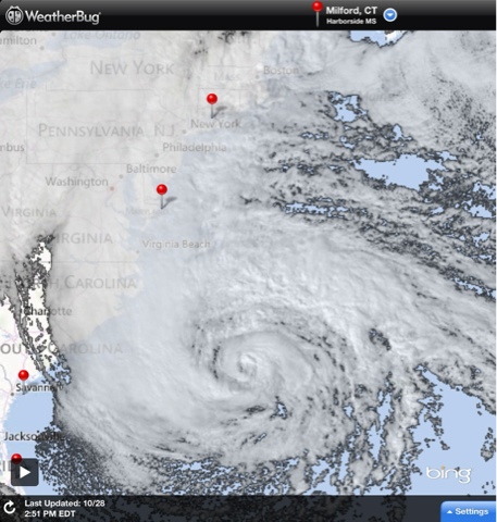
Hurricane Sandy: Boarding up
Some people are taking precautions, especially along the water, where they are boarding up windows! 
Hurricane Sandy: Evacuate along the shore!
New estimates call for a storm surge of 8-10 feet in Long Island Sound! This would be twice as bad as Tropical Storm Irene, which did horrible damage! I highly recommend anyone who lives on the water should evacuate, this storm surge could be the worst in decades!!! 
Saturday, October 27, 2012
Latest European Model 10/27/12
European model, which has been predicting sandy for a week, latest run takes Sandy (or the hybrid) will hit northern NJ as a 956 mb low! If this is true it's a worst case scenario for NYC and Long Island Sound! 

10/26/12 11PM NHC FORECAST PATH HURRICANE SANDY
This path just looks bizarre! It's heading straight for New England as a hurricane and then almost turns due west into Delaware?... Not sure if the left turn is going to be that dramatic! 
Late night GFS Model- perfect storm or worst case scenario?
Actually it's both! Crazy image never thought I would see this on the weather maps! Bad news for NYC metro area, including coastal CT! 
Friday, October 26, 2012


Subscribe to:
Posts (Atom)