
Monday, October 29, 2012
First tree down! Hurricane Sandy!
A pear tree just fell in my neighbors yard on their deck! Weird thing is that this same tree cracked a year ago today during "snowtober" and landed on my deck!
CT forecasted Wind Gusts! 10/29/12
Here's a map from WTNH an ABC affiliate out of New Haven predicting peak wind gust around 90MPH here along the CT Shore for later today and tonight! 
CT Mandatory Evacuations
This is a screen grab of WFSB a Hartford, CT news station of coastal towns with mandatory evacuations. As you can see its almost all the towns! These evacuations are for people right on the water! 
Ocean City, MD beach cams 10/29/12
Here are some screenshots of the Ocean City, Maryland beach and Boardwalk webcams. So far flooding has been bad, the ocean has reached the boardwalk in many areas and there are reports that the Ocean City fishing pier has partially fallen into the ocean, and probably won't make it through the storm! 


Sunday, October 28, 2012
Hurricane Sandy satellite image
Here is a satellite image of Hurricane Sandy off weatherbug. The red pin on the top is where I live, Milford, CT. The pin near the center of the picture is Ocean City, MD. It's a beautiful storm but very dangerous 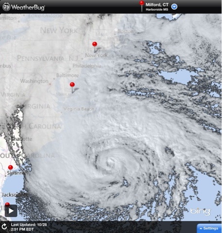
Hurricane Sandy: Boarding up
Some people are taking precautions, especially along the water, where they are boarding up windows! 
Hurricane Sandy: Evacuate along the shore!
New estimates call for a storm surge of 8-10 feet in Long Island Sound! This would be twice as bad as Tropical Storm Irene, which did horrible damage! I highly recommend anyone who lives on the water should evacuate, this storm surge could be the worst in decades!!! 
Saturday, October 27, 2012
Latest European Model 10/27/12
European model, which has been predicting sandy for a week, latest run takes Sandy (or the hybrid) will hit northern NJ as a 956 mb low! If this is true it's a worst case scenario for NYC and Long Island Sound! 

10/26/12 11PM NHC FORECAST PATH HURRICANE SANDY
This path just looks bizarre! It's heading straight for New England as a hurricane and then almost turns due west into Delaware?... Not sure if the left turn is going to be that dramatic! 
Late night GFS Model- perfect storm or worst case scenario?
Actually it's both! Crazy image never thought I would see this on the weather maps! Bad news for NYC metro area, including coastal CT! 
Friday, October 26, 2012


Thursday, October 25, 2012

Thursday, October 4, 2012


Subscribe to:
Posts (Atom)