Showing posts with label Hurricane. Show all posts

Friday, August 7, 2015

Summer Under the Stars - Katharine Hepburn on TCM! AKA 1938 Hurricane Survivor!

Summer Under the Stars is an awesome program that Turner Classic Movies channel runs in August every year. Each day they feature a 24 hour movie marathon for a different actor or actress from the past. Every year they show films of great actors and actresses like Bogart, Carey Grant, Bette Davis or Joan Crawford. However, my favorite day is always Katharine Hepburn day, which falls on August 7th this year (2015). 

Katharine Hepburn is one of my favorite actresses from the Golden Age of Hollywood. I also like her because she is a Connecticut native, born in Hartford but raised at her family's summer retreat in Old Saybrook, CT where the Connecticut River meets Long Island Sound. I find her hilarious in her films Bringing Up Baby and The Philadelphia Story, as well as all films she starred in with Spencer Tracey, who she had a long term affair with! 

So you might be wondering why I'm talking about Katharine Hepburn, classic movies and Summer Under the Stars on a weather blog...Well, one of the other reasons I love Katharine Hepburn so much is that she survived the same hurricane that my grandmother lived through. She was in Old Saybrook on the day of the infamous Great New England Hurricane of 1938, aka The Long Island express. She had even gone swimming in Long Island Sound that very morning. Her waterfront home was destroyed by the storm and she barely got out alive but a hurricane was no match for a strong woman like Katharine Hepburn! Although her house was destroyed, she showed up the next day to start cleaning up the destruction and even posed for a few publicity photos. Check them out on my hub

Check out the rest of the photos and the story at my article on Hubpages titled: "Katharine Hepburn, the Hollywood Legend and Hurricane Survivor"

Friday, June 12, 2015

Napatree Point on Memorial Day Weekend 2015

It's a few weeks past Memorial Day but I figured I would post these pictures now that the unofficial start to summer is in full swing and it's actually warming up! On Memorial Day weekend, I went to one of my favorite beaches in New England, Napatree Point in Watch Hill, Rhode Island. It's a 1.5 mile long spit of sand that juts out west from the historic district of Watch Hill. From Napatree, you can see Rhode Island, Connecticut and even Fisher's Island, New York! 

The beautiful stretch of sand is currently a nature preserve but it once was government land with a fort in the first decade of the 1900's. The remains of the fort still exist at the western point of the beach, slightly hidden by the growing brush and sand dunes. The fort, Fort Mansfield, was built in 1901 and then removed from the list of active posts in 1909. In the late 1920's the United States government sold the land to a private developer who built homes on the sandy stretch of beach. These homes would only last a decade as well. In 1938, the Great New England Hurricane devastated the area and Napatree Point, destroying all the homes built on the peninsula, leaving nothing but the foundation of Fort Mansfield.  There hasn't been any development on the stretch of land since and now it's a nature preserve where people can enjoy the beautiful beach and endangered birds, like the pipping plover, can nest! 

The beach is absolutely beautiful and pretty clean. Memorial Day was a little early this year and although the sun was out, the wind was off the still frigid waters, by the afternoon beach goers were wrapped up in their hoodies and beach blankets. 

 If you walk down far enough, you feel as if you are on a deserted island. It's the perfect location for a quite beach day! 


The above photo was taken from the top of one of the sand dunes, looking east towards Watch Hill. Notice the long stretch of beautiful beach! 


The colors of the white sand, green dune grass, blue water and blue sky make for a perfect paradise on Napatree Point! 


Another view of Napatree, looking east towards Watch Hill. 


An artsy photo of some branches on a sand dune, looking out over Block Island Sound. Branches, debris and grass will build up the sand dune, protecting the strip of land from eroding into the surf! 


Could you ask for a more perfect beach spot? 


Friday, May 8, 2015

SubTropical Storm Ana Forms! What is a SubTropical Storm?

An the 2015 Atlantic Hurricane Season has begun! Granted the official start is June first, the first named tropical system of the season has formed off the coast of South Carolina. This storm is classified as a subtropical storm and her name is Ana. Ana is expected to make landfall around the North Carolina/South Carolina border this weekend. Below is a high resolution satellite image of subtropical storm Ana on Friday May 8, 2015. 


A subtropical storm is defined as 
"A non-frontal low-pressure system that has characteristics of both tropical and extratropical cyclones. Like tropical cyclones, they are non-frontal, synoptic-scale cyclones that originate over tropical or subtropical waters, and have a closed surface wind circulation about a well-defined center. In addition, they have organized moderate to deep convection, but lack a central dense overcast. Unlike tropical cyclones, subtropical cyclones derive a significant proportion of their energy from baroclinic sources, and are generally cold-core in the upper troposphere, often being associated with an upper-level low or trough." (NOAA


Above is the current projected path of subtropical storm Ana, released by the National Hurricane Center.
Although we're off to an early start to the hurricane season, it doesn't mean that we're going to have an active one. In fact the 2015 Colorado State University forecast calls for a below average season. Below is a chart I made with the CSU prediction for the 2015 Atlantic Hurricane Season. Notice all categories are predicted to be below average. 


Sunday, March 22, 2015

Awesome Weather GIFS

Weather has fascinated people for ages, who isn't attracted to the beauty of a thunderstorm or peacefulness of a snowstorm? Yes these events can be dangerous but they are also nature's moving art, a canvas that is forever changing, giving a brief moment of beauty before the next one is created. 

However, with the creation of photographs, film and the Internet, these moments of natural beauty have been captured and enjoyed over and over again. 

From striking photos to front row seat videos of storms, we can also thank the Internet for capturing such beauty. This time in the form of GIFS. 

What's more beautiful (and dangerous) than the electrifying dance of lightning in a thunderstorm?


There's nothing like a winter wonderland, a landscape glowing in the snow, as peaceful flakes fall from the sky.


Lightning may need to be slowed down to see its electrifying dance but sometimes the beauty of weather is discovered over time. Like this time lapse GIF of a snow squall moving into a city. 


Finally, not all of nature's beauty can be seen from ground level. Sometimes a view from 1,000's of miles above will reveal the beauty below. 


Sunday, November 16, 2014

It's a 'CAT'urricane!

It's a 'CAT'urricane!!! Well, not really, it's just a funny GIF I came across on Tumblr. It's a well known fact that cat's rule the internet. Let's face it, how many times have you been completely drawn into watching a cat do something funny on youtube, or see a funny cat photo?  It could be every day!  

Weather can also be a very intense and crazy part of the internet as well. Weather is like the cat's cousin, and 10th in line to the throne. It has it's moments but sadly it will never completely take over the internet like cats do. But what if we combined them? 

So as part of your daily dose of the internet ruler (cats) enjoy watching this cat spin on top of a hurricane all day long! Cat's and weather should go together more often! 

Tuesday, April 29, 2014

Blue Skies Above: Hurricane Sandy Cause Storm Surge in Ft Lauderdale! (Video)


Believe it or not, but this video is actually a result of Hurricane Sandy! Yes, the storm was so massive, and such a monster, that it sent storm surge all the way down the east coast to Ft. Lauderdale Beach in Florida.  On the morning of October 28, 2012, Hurricane Sandy was about to take her left hand turn into the coast of New Jersey, but it sent swells out in all direction, impacting people and beaches far and wide!  

These swells, combined with an astronomical high tide, sent the ocean crashing over the dunes and right into the stress of Ft Lauderdale Beach. Pretty impressive considering the storm was close to 1,000 miles to the northeast! Sunrise Blvd was inundated with water, shocking many considering the skies were crystal blue and the weather was beautiful.

It truly is remarkable to see the strength and power of these storms!

Monday, December 3, 2012

Super Typhoon Bopha! 12-3-12

Hurricane Sandy was bad here on the East Coast, there is no denying that, but Super Typhoon Bopha in the western Pacific is terrifying!! The super typhoon made landfall in the Philippines on December 3, 2012 with winds of 160 mph!!! 160 mph!!! That's just crazy!!

I am not familiar with the Philippines' warning system or response to these storms, although they do experience them often. I hope everyone is safe tonight in the impacted zone!


Below is a satellite image from earlier this morning via The Weather Channel, via NOAA of Bopha approaching the Philippines, almost looks like a textbook example!

Wednesday, November 7, 2012

More Photos from today's Snow Storm


Hurricane last week, Snow this week!

Last week was hurricane Sandy, this week a Nor'Easter with snow and sleet! The weather has been crazy! It's already sticking! Especially at the beach which hasn't even recovered yet from the storm as you can see in the second picture!

Saturday, November 3, 2012

Crazy Waves in Ocean City, MD from Sandy

Just found this video of giant waves in Ocean City, MD last Monday October 29, 2012 as Hurricane Sandy passed by.  Lucky enough Ocean City, MD wasn't has devastated as the Jersey Shore. 


Sunday, October 28, 2012

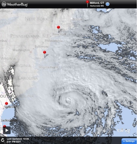
Hurricane Sandy satellite image

Here is a satellite image of Hurricane Sandy off weatherbug. The red pin on the top is where I live, Milford, CT. The pin near the center of the picture is Ocean City, MD. It's a beautiful storm but very dangerous

Saturday, October 27, 2012

Late night GFS Model- perfect storm or worst case scenario?

Actually it's both! Crazy image never thought I would see this on the weather maps! Bad news for NYC metro area, including coastal CT!